10 Iconic Images of the Earth from Space
To see our planet from space is a powerful experience. It’s humbling, beautiful and inspiring. I hope one day more people will have the ability to see our home from space (myself included!). For now, please enjoy these ten breathtaking views of Earth from space. Images courtesy of NASA.
1. The Pale Blue Dot

This narrow-angle color image of the Earth, dubbed ‘Pale Blue Dot’, is a part of the first ever ‘portrait’ of the solar system taken by Voyager 1. The spacecraft acquired a total of 60 frames for a mosaic of the solar system from a distance of more than 4 billion miles from Earth and about 32 degrees above the ecliptic. From Voyager’s great distance Earth is a mere point of light, less than the size of a picture element even in the narrow-angle camera. Earth was a crescent only 0.12 pixel in size.
Coincidentally, Earth lies right in the center of one of the scattered light rays resulting from taking the image so close to the sun. This blown-up image of the Earth was taken through three color filters — violet, blue and green — and recombined to produce the color image. The background features in the image are artifacts resulting from the magnification. [Source]
2. The Blue Marble
This spectacular “blue marble” image was the most detailed true-color image of the entire Earth to date when released in 2002. Using a collection of satellite-based observations, scientists and visualizers stitched together months of observations of the land surface, oceans, sea ice, and clouds into a seamless, true-color mosaic of every square kilometer (.386 square mile) of our planet.
Much of the information contained in this image came from a single remote-sensing device-NASA’s Moderate Resolution Imaging Spectroradiometer, or MODIS. Flying over 700 km above the Earth onboard the Terra satellite, MODIS provides an integrated tool for observing a variety of terrestrial, oceanic, and atmospheric features of the Earth. The land and coastal ocean portions of these images are based on surface observations collected from June through September 2001 and combined, or composited, every eight days to compensate for clouds that might block the sensor’s view of the surface on any single day.
Two different types of ocean data were used in these images: shallow water true color data, and global ocean color (or chlorophyll) data. Topographic shading is based on the GTOPO 30 elevation dataset compiled by the U.S. Geological Survey’s EROS Data Center. MODIS observations of polar sea ice were combined with observations of Antarctica made by the National Oceanic and Atmospheric Administration’s AVHRR sensor—the Advanced Very High Resolution Radiometer. The cloud image is a composite of two days of imagery collected in visible light wavelengths and a third day of thermal infra-red imagery over the poles. Global city lights, derived from 9 months of observations from the Defense Meteorological Satellite Program, are superimposed on a darkened land surface map. [Source]
You may also recognize this image as it was the default image on the iPhone when it was released in 2007.
3. ‘Earth Rise’ as Seen from Lunar Surface
This incredible image of the Earth rise was taken during lunar orbit by the Apollo 11 mission crew in July of 1969. The first manned lunar mission, Apollo 11 launched aboard a Saturn V launch vehicle from the Kennedy Space Center, Florida on July 16, 1969 and safely returned to Earth on July 24, 1969. The 3-man crew aboard the flight consisted of Neil A. Armstrong, commander; Michael Collins, Command Module pilot; and Edwin E. Aldrin Jr., Lunar Module pilot.
Carrying astronauts Neil A. Armstrong and Edwin E. Aldrin, Jr., the Lunar Module (LM) “Eagle” was the first crewed vehicle to land on the Moon. Astronaut Collins piloted the Command Module in a parking orbit around the Moon. The LM landed on the moon’s surface in the region known as Mare Tranquilitatis (the Sea of Tranquility). The crew collected 47 pounds of lunar surface material which was returned to Earth for analysis. The surface exploration was concluded in 2.5 hours. With the success of Apollo 11, the national objective to land men on the Moon and return them safely to Earth had been accomplished. The Saturn V launch vehicle was developed by the Marshall Space Flight Center (MSFC) under the direction of Dr. Wernher von Braun. [Source]
4. First Picture of the Earth and Moon in a Single Frame
This picture of a crescent-shaped Earth and Moon — the first of its kind ever taken by a spacecraft — was recorded Sept. 18, 1977, by NASA’s Voyager 1 when it was 7.25 million miles (11.66 million kilometers) from Earth. The Moon is at the top of the picture and beyond the Earth as viewed by Voyager. In the picture are eastern Asia, the western Pacific Ocean and part of the Arctic. Voyager 1 was directly above Mt. Everest (on the night side of the planet at 25 degrees north latitude) when the picture was taken.
The photo was made from three images taken through color filters, then processed by the Jet Propulsion Laboratory’s Image Processing Lab. Because the Earth is many times brighter than the Moon, the Moon was artificially brightened by a factor of three relative to the Earth by computer enhancement so that both bodies would show clearly in the print. Voyager 2 was launched Aug. 20, 1977, followed by Voyager 1 on Sept. 5, 1977, en route to encounters at Jupiter in 1979 and Saturn in 1980 and 1981. JPL manages the Voyager mission for NASA. [Source]
5. The Earth Terminator
The two images above were taken during the Apollo 11 Mission. In it we see the Earth terminator. On Earth, the terminator is a circular line with a diameter that is approximately that of the Earth. The terminator passes through any point on the Earth’s surface twice a day, once at sunrise and once at sunset, apart from polar regions where this only occurs when the point is not experiencing midnight sun or polar night.
The line separates the portions of the Earth experiencing daylight from the portion of the planet experiencing darkness. While one half of the Earth is illuminated at any point in time (with exceptions during eclipses), the location of the terminator line varies by time of day due to the rotation of the Earth on its axis as well as the revolution of the Earth around the Sun.
The terminator line also varies by time of year: on Earth the angle of the line is almost parallel to lines of longitude during the equinoxes, and at its maximum angle of approximately 23.5 degrees during the solstices. At the equator, under flat conditions (no obstructions such as mountains; or at a height above any such obstructions), the terminator line moves at approximately 1600 kilometers per hour (1000 miles per hour). This speed can appear to be increased when near obstructions—such as the height of a mountain, for example—as the shadow of the obstruction will be broadcast over the ground in advance of the terminator line along a flat landscape. The speed of the terminator line decreases as one approaches the poles, where it can reach a speed of zero (full-day sunlight or darkness). [Source: Wikipedia]
6. The Earth and Moon as Viewed from Mars
This is the first image of Earth ever taken from another planet that actually shows our home as a planetary disk. Because Earth and the Moon are closer to the Sun than Mars, they exhibit phases, just as the Moon, Venus, and Mercury do when viewed from Earth. As seen from Mars by MGS on 8 May 2003 at 13:00 GMT (6:00 AM PDT), Earth and the Moon appeared in the evening sky.
The MOC Earth/Moon image has been specially processed to allow both Earth (with an apparent magnitude of -2.5) and the much darker Moon (with an apparent magnitude of +0.9) to be visible together. The bright area at the top of the image of Earth is cloud cover over central and eastern North America. Below that, a darker area includes Central America and the Gulf of Mexico. The bright feature near the center-right of the crescent Earth consists of clouds over northern South America.
The image also shows the Earth-facing hemisphere of the Moon, since the Moon was on the far side of Earth as viewed from Mars. The slightly lighter tone of the lower portion of the image of the Moon results from the large and conspicuous ray system associated with the crater Tycho. A note about the coloring process: The MGS MOC high resolution camera only takes grayscale (black-and-white) images. To “colorize” the image, a Mariner 10 Earth/Moon image taken in 1973 was used to color the MOC Earth and Moon picture.
The procedure used was as follows: the Mariner 10 image was converted from 24-bit color to 8-bit color using a JPEG to GIF conversion program. The 8-bit color image was converted to 8-bit grayscale and an associated lookup table mapping each gray value of the image to a red-green-blue color triplet (RGB). Each color triplet was root-sum-squared (RSS), and sorted in increasing RSS value. These sorted lists were brightness-to-color maps for the images. Each brightness-to-color map was then used to convert the 8-bit grayscale MOC image to an 8-bit color image. This 8-bit color image was then converted to a 24-bit color image. The color image was edited to return the background to black. [Source]
7. Earth Rise as Seen from the Dark Side of the Moon
The Apollo 16 crew captured this Earthrise with a handheld Hasselblad camera during the second revolution of the moon. Identifiable craters seen on the moon include Saha, Wyld and Saenger. Much of the terrain seen here is never visible from the Earth, as the command module was passing onto what is known as the ‘dark side’ of the moon. Apollo 16 launched on April 16, 1972 and landed on the moon on April 20. The mission was commanded by John Young; Thomas K. Mattingly II was the command module pilot and Charles M. Duke, Jr. served as the lunar module pilot. [Source]
The far side of the Moon, sometimes called the “dark side of the Moon” in the sense that it is in a radio blackout in respect to transmitters on Earth, is the lunar hemisphere that is permanently turned away, and not visible from the surface of the Earth. The far hemisphere was first photographed by the Soviet Luna 3 probe in 1959, and was first directly observed by human eyes when the Apollo 8 mission orbited the Moon in 1968. To date, there has been no ground exploration of the far side of the Moon.
Tidal forces from Earth have slowed down the moon’s rotation so that the same side is always facing the Earth, a phenomenon called tidal locking. The other face, most of which is never visible from the Earth (18% of it can be observed over time due to libration) is shown here. Libration is an oscillating motion of orbiting bodies relative to each other, notably including the motion of the Moon relative to Earth. [Source: Wikipedia]
8. Apollo 17 Astronaut Adjusts Flag on Lunar Surface with Earth in Background
In this Apollo 17 onboard photo, Mission Commander Eugene A. Cernan adjusts the U.S. flag deployed upon the Moon. The seventh and last manned lunar landing and return to Earth mission, the Apollo 17, carrying a crew of three astronauts: Cernan; Lunar Module pilot Harrison H. Schmitt; and Command Module pilot Ronald E. Evans, lifted off on December 7, 1972 from the Kennedy Space Flight Center (KSC).
The mission marked the longest Apollo mission, 504 hours, and the longest lunar surface stay time, 75 hours, which allowed the astronauts to conduct an extensive geological investigation. They collected 257 pounds (117 kilograms) of lunar samples with the use of the Marshall Space Flight Center developed LRV. The mission ended on December 19, 1972. [Source]
9. Earth’s Crest Over the Lunar Horizon
This view of the Earth’s crest over the lunar horizon was taken during the Apollo 15 lunar landing mission. Apollo 15 launched from the Kennedy Space Center (KSC) on July 26, 1971 via a Saturn V launch vehicle. Aboard was a crew of three astronauts including David R. Scott, Mission Commander; James B. Irwin, Lunar Module Pilot; and Alfred M. Worden, Command Module Pilot.
The first mission designed to explore the Moon over longer periods, greater ranges and with more instruments for the collection of scientific data than on previous missions, the mission included the introduction of a $40,000,000 lunar roving vehicle (LRV) that reached a top speed of 16 kph (10 mph) across the Moon’s surface. The successful Apollo 15 lunar landing mission was the first in a series of three advanced missions planned for the Apollo program. Apollo 15 televised the first lunar liftoff and recorded a walk in deep space by Alfred Worden. Both the Saturn V rocket and the LRV were developed at the Marshall Space Flight Center. [Source]
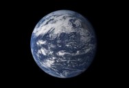
10. The Blue Planet
Viewed from space, the most striking feature of our planet is the water. In both liquid and frozen form, it covers 75% of the Earth’s surface. It fills the sky with clouds. Water is practically everywhere on Earth, from inside the rocky crust to inside our cells.
This detailed, photo-like view of Earth is based largely on observations from the Moderate Resolution Imaging Spectroradiometer (MODIS) on NASA’s Terra satellite. It is one of many images of our watery world featured in a new story examining water in all of its forms and functions. Here is an excerpt: “In all, the Earth’s water content is about 1.39 billion cubic kilometers (331 million cubic miles), with the bulk of it, about 96.5%, being in the global oceans. As for the rest, approximately 1.7% is stored in the polar icecaps, glaciers, and permanent snow, and another 1.7% is stored in groundwater, lakes, rivers, streams, and soil.
Only a thousandth of 1% of the water on Earth exists as water vapor in the atmosphere. Despite its small amount, this water vapor has a huge influence on the planet. Water vapor is a powerful greenhouse gas, and it is a major driver of the Earth’s weather and climate as it travels around the globe, transporting heat with it.
For human needs, the amount of freshwater for drinking and agriculture is particularly important. Freshwater exists in lakes, rivers, groundwater, and frozen as snow and ice. Estimates of groundwater are particularly difficult to make, and they vary widely. Groundwater may constitute anywhere from approximately 22 to 30% of fresh water, with ice accounting for most of the remaining 78 to 70%.” [Source]
If you enjoyed this post, the Sifter highly recommends: