Google Adds First Underwater Panoramas to Maps and Street View

Google has just added the very first underwater panoramic images to Google Maps and Street View. In their ongoing quest to map the globe, it was a matter of time before they ventured under the water that covers over 70% of our globe.
To pull of this feat Google has partnered with the Catlin Seaview Survey, who have built an incredible camera called the SVII (Seaview II) which does for the underwater what Google’s Street View cameras do for dry land.
Together, their goal is to bring unprecedented accessibility to our Earth’s oceans through ‘virtual diving’. Giving you the power to navigate under the seas with your desktop, laptop, tablet or smartphone.
Below you will find snapshots and Google Maps Street View links to the underwater panoramas currently available. Enjoy your ‘virtual dive’ my friends!
Google Maps Street View Underwater
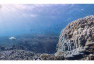
Heron Island, Great Barrier Reef, Australia
Heron Island is a coral cay in the southern Great Barrier Reef. In this imagery, you can walk along the Heron Island Resort, past the pool, off the rocks and dive into the water, where you can see coral and sea turtles. You can walk back out of the water onto the sand and walk back around the island to the resort. [Source]
Lady Elliot Island, Great Barrier Reef, Australia
This is the southernmost coral cay of the Great Barrier Reef, and features a diver encountering a manta ray. It is in the green zone, which is offered the highest protection by the Great Barrier Reef Marine Park Authority. [Source]
Molokini Crater – Maui, Hawaii, United States
Molokini is a crescent-shaped, partially submerged volcanic crater which forms a small islet located in Alalakeiki Channel between the islands of Maui and Kaho?olawe. It is one of the top 10 dive spots in the world. [Source]
Hanauma Bay – Oahu, Hawaii, United States
It is a marine embayment formed within a volcanic cone and located along the southeast coast of the Island of O?ahu (just east of Honolulu) in the Hawaiian Islands. Hanauma is one of the most popular tourist destinations on the Island and has suffered somewhat from overuse. [Source]
Apo Islands – Dauin, Philippines
Apo Island is a volcanic island which is surrounded by a marine reserve. At present, the island is home to over 650 documented species of fish and estimated to have over 400 species of corals. Most of the Philippines’ 450 species of coral can be found here, from tiny bubble corals to huge gorgonian sea fans and brain corals. [Source]
Wilson Island, Great Barrier Reef, Australia
Wilson Island is an important turtle and bird rookery fringed by a white coral beach and covered with pisonia forest. From November to March, the island is home to wedge-tailed shearwaters and green turtles; from June to September, humpback whales can be seen going to and from their winter feeding grounds. [Source]
The SVII Camera by Catlin Seaview Survey
The Catlin Seaview SVII camera does for the underwater, what Google’s Street View did for dry land. Rapid-fire 360 degree images are taken every 3 seconds whilst traveling at a speed of approximately 4km/h. Images are then stitched together and published online in a fashion that allows anyone with a desktop, laptop, tablet or smartphone to self-navigate a ‘virtual dive’ in stunning high-resolution.
For each image captured, a geo-location and camera direction is also recorded, meaning it’s possible to retake the photograph at a later date from the exact same camera position as the original. The positive implications for the scientific community and the long term monitoring of reefs are huge. With a tablet and underwater housing it’s a simple process for anyone to revisit any part of the reef, retake an image and make comparisons over time.
Designed for global rollout, great attention was paid to making the SVII far more user-friendly than its predecessor the SVI. Operated entirely by a tablet, there is no longer the need to open the housing to change settings, download imagery or recharge, halving the overall time for each survey.
There are currently only two SVII’s in in the world. We’ve named one “Sylvia” after oceanographer, aquanaut and author Sylvia Earle, the second is named “Ron” after the legendary shark photographer and friend of the Catlin Seaview Survey, the late Ron Taylor.
If you enjoyed this post, the Sifter highly recommends: