August 24, 2015 at 9:46 am
The Jefferson Grid Shows One Square Mile of Land from Above (15 Photos)
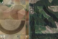
The Jefferson Grid is a fascinating Instagram account that shows one square mile of our planet (sometimes the grids are larger/smaller) as seen on Google Earth.
The idea to use one square mile was inspired the Public Land Survey System (PLSS), a surveying method developed and used in the United States to, ‘plat, or divide, real property for sale and settling.’ [source]
Below is a small gallery of my personal favorites and you can find 70+ more on Instagram by following @the.jefferson.grid
[via Kottke]
If you enjoyed this post, the Sifter
highly recommends:
")