
Our world is a complex network of people, places and things. Maps are a great tool and can help us understand how we are all connected. Below you will find a collection of informative maps that will hopefully teach you something new and give you a fresh perspective of our amazing planet and those that inhabit it.
1. If You’re on the Beach, This is What’s Across the Ocean


The map above shows the countries that are due east and west from points along the coasts of North and South America. Many small island nations are (perhaps unfairly) excluded for ease of reading. [source]
2. Point Nemo: The Farthest Place on Earth from Land


The oceanic pole of inaccessibility (48°52.6′S 123°23.6′W) is the place in the ocean that is farthest from land. It lies in the South Pacific Ocean, 2,688 km (1,670 mi) from the nearest lands: Ducie Island (part of the Pitcairn Islands) in the north, Motu Nui (part of the Easter Islands) in the northeast, and Maher Island (near the larger Siple Island, off the coast of Marie Byrd Land, Antarctica) in the south. Chatham Island lies farther west, and Southern Chile in the east. This location is also referred to as “Point Nemo”, a reference to Jules Verne’s Captain Nemo. [source]
3. Air Traffic Across the Globe in a Single 24-Hour Period

4. How Google Maps Alters Borders Based on the Country You’re Viewing From


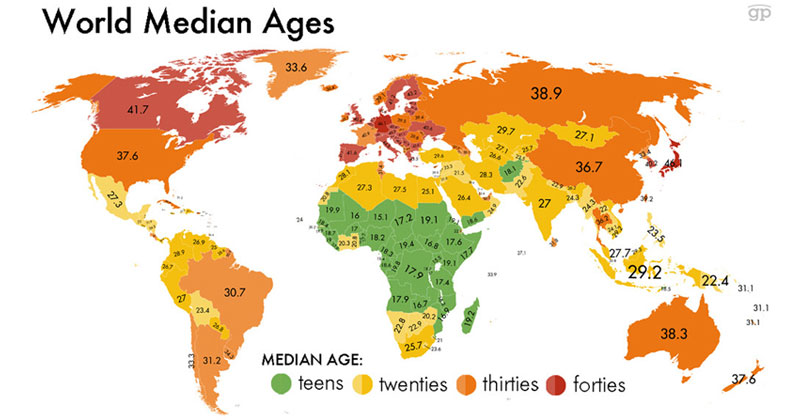
5.


6. The Most Consumed Alcoholic Beverage by Country


7. Countries That Look Like Other Countries (+Bonus States)


8.


9. The Earth’s Seasons


10.


11. The Word for Bear in Various European Languages


12. Percentage of People Having Sex Weekly by Country


13. Camouflages of the World


14. Which Exports Make Your Country the Most Money


15.


16. Tech Companies in Silicon Valley/San Francisco


17. Longest Distance You Can Travel Without Crossing Major Bodies of Water


The longest distance you can travel between two points in straight line without crossing any ocean or any major water bodies goes from Liberia to China. It starts at 5°2’51.59″N 9°7’23.26″W about 10 Km north of Greenville, Liberia and ends at 28°17’7.68″N 121°38’17.31″E near Wenling, China. A 13,589.31 Km walk in a straight line, it crosses 9 time zones and 18 countries and territories: Liberia, Côte d’Ivoire, Burkina Faso, Ghana, Burkina Faso again, Niger, Chad, Libya, Egypt, Israel, the West Bank, Jordan, Iraq, Iran, Turkmenistan, Uzbekistan, Tajikistan, Afghanistan, Tajikistan again and finally China. [source]
18. If North America Were on Jupiter or Mars


19. There are More Wikipedia Articles Inside this Circle than Outside of It


This map points out the highly uneven spatial distribution of (geotagged) Wikipedia articles in 44 language versions of the encyclopaedia. Slightly more than half of the global total of 3,336,473 articles are about places, events and people inside the red circle on the map, occupying only about 2.5% of the world’s land area. The article locations were mapped on top of a dataset obtained from Natural Earth using Buckminster Fuller’s Dymaxion map projection that has little distortion of shape and area and highlights that there is no ‘right way up’.
This uneven distribution of knowledge carries with it the danger of spatial solipsism for the people who live inside one of Wikipedia’s focal regions. It also strongly underrepresents regions such as the Middle East and North Africa as well as Sub-Saharan Africa. In the global context of today’s digital knowledge economies, these digital absences are likely to have very material effects and consequences. [source]
20. Greenland and Africa – Mercator Projection vs Actual Size


21. World’s Most and Least Ethnically Diverse Countries


22.


23. Access to Sanitation Around the Globe


24. If the Polar Ice Caps Completely Melted


25. Nutella and the Global Economy


26. People Tweeting About Sunrises Over a 24-Hour Period


27. Fiber Optic Cables Around the World


28. Key Import Sources Around the World


29. Major Russian Gas Pipelines Into Europe


30.


31.


32. Relief Maps of Earth with Exaggerated Mountain Ranges


If you enjoyed this post, the Sifter
highly recommends:

