Canada Mapped by Trails, Roads, Streets and Highways
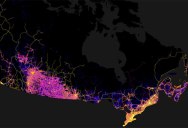
Data lover and Geography PhD candidate Robbi Bishop-Taylor uses open-source GIS software to generate high-resolution maps of the world. In a recent project, Bishop-Taylor created a high-resolution map of Canada’s trails, roads, streets and highways; weighted and colored by size (from small unsealed trails and roads in blue to freeways in bright yellow).
The map was created with QGIS using the following datasets: Government of Canada; Natural Resources Canada; Earth Sciences Sector; Canada Centre for Mapping and Earth Observation. 2015. GeoBase – National Road Network (NRN) v12.0. Ottawa, ON: Department of Natural Resources Canada.
The end result reminds me of our own circulatory system, a fitting comparison for a country’s ‘lifeblood’, its transportation system. Not surprisingly, there are more roads on the maps within 200 km (120 miles) of the US border than there are in the remaining 3,800 km (2,400 miles) of Canada to the north.
If you’re interested in high-res prints, they are available through Bishop-Taylor’s Etsy Shop, Earth Art Australia. For more interesting maps be sure to check out Earth Art Australia on Facebook and Instagram
[via Earth Art Australia on reddit]
1. Canada

2. Toronto, Ottawa, Montreal and Quebec City (Southern Ontario and Quebec)

3. New Brunswick, Nova Scotia and Prince Edward Island

4. Edmonton and Calgary (central/southern Alberta and Saskatchewan)

5. Vancouver and south-western British Columbia

6. Southern Manitoba and western Ontario

7. Nunavut, The Yukon and the Northwest Territories


Sign up to get our BEST stories of the week straight to your inbox.


