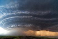
Picture of the Day: Oklahoma Supercell

Seen here is an intimidating storm cloud near Panhandle, Oklahoma. The imposing cloud’s grandeur is enhanced by the broad expanse of flat land, the so-called ‘Great Plains‘ region of the United States. Most of Oklahoma lies in an area known as Tornado Alley, characterized by frequent interaction between cold and warm air masses producing severe weather. An average 62 tornadoes strike the state per year—one of the highest rates in the world.
A supercell is a thunderstorm that is characterized by the presence of a mesocyclone: a deep, persistently rotating updraft. Of the four classifications of thunderstorms (supercell, squall line, multi-cell, and single-cell), supercells are the least common and have the potential to be the most severe. Supercells are often isolated from other thunderstorms, and can dominate the local climate up to 32 kilometres (20 mi) away. [source]
Supercells can occur anywhere in the world under the right pre-existing weather conditions, but they are most common in the Great Plains of the United States in an area known as Tornado Alley and in the plains of Argentina, Uruguay and southern Brazil. [source]

Sign up to get our BEST stories of the week straight to your inbox.


