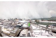
Picture of the Day: The Snow Wall
Western New York is currently experiencing a historic snowstorm with another 2 – 3 ft of snow expected to fall in the Buffalo area by late Thursday. Driven by the lake effect, a massive snowstorm dumped upwards of 60 inches (152 cm) on parts of Western New York. [source]
In the dramatic capture above by Joseph DeBenedicts, we see the ‘lake-effect’ in full effect. The photo was taken from the 31st floor of Buffalo’s tallest building, One Seneca Tower. You can also see an amazing timelapse taken by Jason Holler and Joseph DeBenedictis below.
Lake-effect snow is produced during cooler atmospheric conditions when cold winds move across long expanses of warmer lake water, providing energy and picking up water vapor, which freezes and is deposited on the leeward shores. The effect is enhanced when the moving air mass is uplifted by the orographic influence of higher elevations on the downwind shores. This uplifting can produce narrow but very intense bands of precipitation, which deposit at a rate of many inches of snow each hour, often resulting in copious snowfall totals. The areas affected by lake-effect snow are called snowbelts. [source]

Sign up to get our BEST stories of the week straight to your inbox.


