Greenland’s Icy Surface Has Long Been Hiding A Secret, As New NASA Radar Uncovers The Secret City Hidden 100 Feet Below The Surface

Pexels
We usually think of NASA scientists as working specifically on projects to be launched into space, but they also carry out important work on investigating and safeguarding our home planet.
And sometimes, some of that experimental and exploratory work reveals secrets as fascinating as the information obtained from other planets.
Because one thing that NASA has access to is tech. Old tech, new tech: a whole lot of tech.
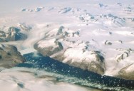
And when NASA scientist Chad Greene was flying aboard a Gulfstream III in Greenland to trial some new tech in April 2024, a surprise sighting showed not only how efficient the new tech really was, but unveiled some of the US’s Cold War secrets, too.
NASA/JPL
On board the flight, Greene was testing NASA’s UAVSAR (Uninhabited Aerial Vehicle Synthetic Aperture Radar). Used to create multi-dimensional maps of large land masses, Greenland was deemed the perfect place to test the radar, as Greene explained in a NASA statement:
“Our goal was to calibrate, validate, and understand the capabilities and limitations of UAVSAR for mapping the ice sheet’s internal layers and the ice-bed interface.”
This project, and the associated technology, are important in our understanding of mostly unexplored areas of our planet like Greenland and Antarctica. The images are key to helping scientists measure the thickness of ice sheets so that we can understand the effects of climate change in these cold regions.
UAVSAR’s images will help us to understand how close we might be to one of the tipping points that will lead to spiralling climate crisis. This will help scientists and governments respond accordingly, as Alex Gardner from NASA’s Jet Propulsion Laboratory continued in the statement:
“Without detailed knowledge of ice thickness, it is impossible to know how the ice sheets will respond to rapidly warming oceans and atmosphere, greatly limiting our ability to project rates of sea level rise.”
And the testing was successful. So successful, in fact, that the images revealed a mysterious settlement below the surface of the ice sheet.
NASA
But what was the mysterious settlement that the radar images unveiled?
The network of tunnels and dwellings was none other than Camp Century, a US Army base from the Cold War, which was built by tunnelling under the ice sheet. Of course, it wasn’t very hospitable and was thus abandoned in 1967. Hence, the NASA scientists were surprised to find it, as Gardner explained:
“We were looking for the bed of the ice and out pops Camp Century. We didn’t know what it was at first.”
Now buried 100 feet below the surface of the ice, Camp Century is well and truly buried. However, thanks to the new images, this relic of the Cold War can still be admired, as Greene notes:
“In the new data, individual structures in the secret city are visible in a way that they’ve never been seen before.”
Will we ever see Camp Century again?
Well, scientists hope now – since the unveiling of the secret facility would mean quite significant ice melt had taken place. And, as NASA warns, this could also unveil all sorts of biological, chemical, and even radioactive waste that had been frozen in time.
If you thought that was interesting, you might like to read about the mysterious “pyramids” discovered in Antarctica. What are they?


Sign up to get our BEST stories of the week straight to your inbox.