How Leonardo da Vinci Made a Google Map in 1502
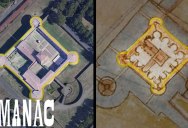
Leonardo da Vinci’s known for his art and inventions — but also his groundbreaking maps, like this one of Imola, Italy. It was a feat of technological and symbolic imagination. And it was pretty accurate, too.
Drafting 1502’s equivalent to a “satellite” map was a massive undertaking, and Leonardo managed to pull it off. His early map helped Italian politician Cesare Borgia construct an idea of the town of Imola that was far more accurate than most contemporary maps. Through the use of careful measurements of angles and pacing out distances using a primitive odometer, Leonardo managed to create a map that was very close to accurate.
This map — an “ichnographic” map — was a step forward in portraying how maps could work to represent geography. Though it’s marked with some inaccuracies, it’s stunningly precise for the time and pushed forward the art of map making. Leonardo’s Imola remains, even today, a remarkably useful guide to the city.