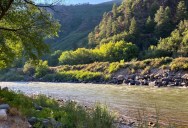
Picture of the Day: Hiking in the Andes
HIKING IN THE ANDES

HDR wizard Trey Ratcliff of the wildly popular Stuck in Customs blog took this ‘painting-esque’ photo while hiking in the Andes.
The Andes is the longest continental mountain range in the world. It is a continual range of highlands along the western coast of South America. This range is about 7,000 km (4,300 mi) long, about 200 km (120 mi) to 700 km (430 mi) wide (widest between 18° south and 20° south latitude), and of an average height of about 4,000 m (13,000 ft). The Andes extend from north to south through seven South American countries: Venezuela, Colombia, Ecuador, Peru, Bolivia, Chile and Argentina.
Along its length, the Andes is split into several ranges, which are separated by intermediate depressions. The Andes is the location of several high plateaux – some of which host major cities such as Quito, Bogotá, Arequipa, Medellín, Sucre, and La Paz. The so-called Altiplano plateau is the world’s second-highest plateau following the Tibetan plateau.
The Andes range is the world’s highest mountain range outside of Asia. The highest peak, Mount Aconcagua, rises to an elevation of about 6,962 m (22,841 ft) above sea level. The peak of Chimborazo in the Ecuadorean Andes is farther from Earth’s centre than any other location on Earth’s surface, due to the equatorial bulge resulting from Earth’s rotation.
The world’s highest volcanoes are in the Andes, including Ojos del Salado on the Chile-Argentina border which rises to 6,893 m (22,615 ft). Fifty other Andean volcanoes also rise above 6,000 m (19,685 ft). [Source: Wikipedia]


Sign up to get our BEST stories of the week straight to your inbox.