Inspired by the geography game GeoGuessr, Alan Taylor, who runs theatlantic.com’s wildly popular In Focus, spent some time recently in Google Maps, finding the edges of their Street View coverage. In the article, Taylor remarks: “I’ve always been drawn to the end of the road, to the edges of where one might be allowed…
GIRAFFE UMBRELLA Photograph by Ben Matthew Wong | twistedsifter.com I took this photo in Tanzania’s Serengeti National Park. It was the middle of the afternoon and the sun was scorching. We drove past this lone giraffe that was getting shade and shelter from the sun by standing under this beautiful Acacia tree.…
Situated between the Bronx and Riker’s Island is a small parcel of land in the East River known as North Brother Island. The island is small, measuring approximately 400 meters x 250 meters. Together with its smaller counterpart South Brother Island, the two have a land area of about 20 acres (81,400 square meters).…
FOREST’S EYE Photograph by Adry on Flickr Located in Nahuel Huapi, Argentina’s oldest national park, is this gorgeous hiking trail known as Sendero de Los Arrayanes. The photo was taking by Flickr user Adry, and she says it winds from Puerto Pañuelo to Lago Moreno. At this particular spot, with the trees…
SUNSET IN LA PAZ Photograph by PEDRO SZEKELY In this photograph by Pedro Szekely we see the city of La Paz, the second largest city in Bolivia after Santa Cruz. It is located in the western part of the country at an elevation of roughly 3,650 m (11,975 ft) above sea level,…
CRASHING WAVES IN THE CARIBBEAN Photograph by rachel_thecat on Flickr A beautiful capture by rachel_thecat on Flickr of crashing waves just off the coast of Pointe-à-Pitre, the largest city in Guadeloupe. Guadeloupe is a Caribbean island located in the Leeward Islands, in the Lesser Antilles, with a land area of 1,628 square…
THE TEMPLE CAVE OF BATU Photograph by TREY RATCLIFF | stuckincustoms.com Batu Caves is a limestone hill which has a series of caves and cave temples in the Gombak district, 13 kilometers (8 mi) north of Kuala Lumpur, Malaysia. It takes its name from the Sungai Batu or Batu River, which flows…
TORONTO FROM ABOVE Photograph by MIKE PALMER @ roamingfocus.ca Taken from a helicopter, we see a breathtaking view of downtown Toronto through the lens of photographer Mike Palmer. The aerial photo is part of a project entitled Born & Raised. Palmer gives himself a single day, from sunrise to sunset, to capture…
The Cupola is an ESA-built observatory module of the International Space Station (ISS). Its seven windows are used to conduct experiments, dockings and observations of Earth. It was launched aboard Space Shuttle mission STS-130 on 8 February 2010 and attached to the Tranquility (Node 3) module. The Cupola’s 80 cm (31 in) window is…
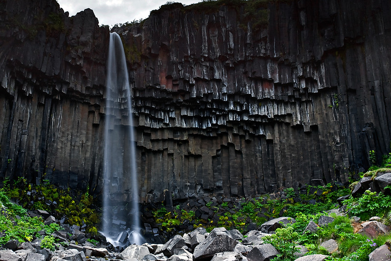
BLACK FALL, ICELAND Photograph by Jon Óskar Hauksson Svartifoss (Black Fall) is a waterfall in Vatnajökull National Park in Iceland and is one of the park’s most popular sights. Svartifoss is surrounded by dark lava columns, which gave rise to its name. Other well-known columnar jointing formations are seen at the Giant’s…