Picture of the Day: The Inhabited Volcanic Island of Aogashima
THE INHABITED VOLCANIC ISLAND OF AOGASHIMA

Aogashima is a volcanic Japanese island in the Philippine Sea, administered by Tokyo and located approximately 358 kilometres (222 mi) south of Tokyo and 64 kilometres (40 mi) south of Hachijojima. It is the southernmost and most isolated inhabited island of the Izu archipelago.
The village of Aogashima administers the island under Hachijo Subprefecture of Tokyo Metropolis. As of 2009, the island’s population was 205. Aogashima is also within the boundaries of the Fuji-Hakone-Izu National Park.
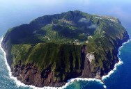
Aogashima is a volcanic island 3.5 km in length with a maximum width of 2.5 km, formed by the overlapping remnants of at least four submarine calderas. The island is surrounded by very steep rugged cliffs of layered volcanic deposits. The southern coast also rises to a sharp ridge forming one edge of a caldera named Ikenosawa with a diameter of 1.5 km. The caldera dominates the island, with one point on its southern ridge, Otonbu with a height of 423 metres (1,388 ft), as the island’s highest point. The caldera is occupied by a secondary cone named Maruyama.
Still considered a Class-C active volcano by the Japan Meteorological Agency, the last eruption of Aogashima was during a four year period from 1781-1785. [Source]


Sign up to get our BEST stories of the week straight to your inbox.