18 Striking Images from Space Show Earth’s Rich Tapestry
The European Space Agency (ESA) is Europe’s gateway to space. An international organisation with 20 Member States, the ESA in its current form was created in 1975. Since then they have shared amazing research and images for the world to learn from. With almost 12,000 high-resolution images available through their website, their extensive archive is a great online resource for research and inspiration.
One particularly striking archive available is Observing the Earth, a collection of satellite images of Earth. As the ESA explains:
“Earth Observation images show the world through a wide-enough frame so that complete large-scale phenomena can be observed to an accuracy and entirety it would take an army of ground-level observers to match. A single satellite image has the potential to show the spread of air pollution across a continent, the precise damage done in a region struck by an earthquake or forest fires, or the entire span of a 500-km hurricane from the calmness of its eye to its outermost storm fronts. Earth Observation provides objective coverage across both space and time. The same space-based sensor gathers data from sites across the world, including places too remote or otherwise inaccessible for ground-based data acquisition.
While satellite acquisitions are most often presented in the form of pictures, they are actually digital data. So the same raw data can be processed with computer software in many different ways to extract whatever information the particular end-user requires.”
Below you will find a selection of the Sifter’s personal favourites. You can see the entire archive on the ESA’s official site.
[h/t Colossal]
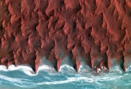
1. Namib Desert

Korea’s Kompsat-2 satellite captured this image over the sand seas of the Namib Desert on 7 January 2012. The blue and white area is the dry river bed of the Tsauchab. Black dots of vegetation are concentrated close to the river’s main route, while salt deposits appear bright white. Running through the river valley, a road connects Sossusvlei to the Sesriem settlement. At the road’s 45th kilometre, seen at the lower-central part of the image, a white path shoots off and ends at a circular parking area at the base of a dune. This is Dune 45, a popular tourist stop on the way to and from Sossusvlei. In this image, there appears to be some shadow on the western side. From this we can deduce that the image was acquired during the late morning.
2. Venice, Italy
The islands that make up the Italian city of Venice and the surrounding Venetian Lagoon are pictured in this image. Snaking through the central districts is the Grand Canal, with the Santa Lucia train station at its northern end and the Saint Mark Basin at its southern end. Zooming in, we can see water buses and taxis navigating the canal and gondolas docked along the edge. The square island to the north is San Michele. Once a prison island, it became a cemetery when Napoleon’s occupying forces declared burial on the main islands unsanitary. This image was acquired on 22 June 2008 by Ikonos-2, a commercial satellite that provides panchromatic and multispectral high-resolution imagery.
3. Algerian Sahara
The image shows the extraordinary landscape of the Tanezrouft Basin, one of the most desolate parts of the Sahara desert, in south-central Algeria. The region is known as ‘land of terror’ because of its lack of water and vegetation. As visible, this region is characterised by dark sandstone hills, steep canyon walls, salt flats (white), stone plateaus, sandstone outcrop patterns of concentric loops and sprawling seas of multi-storey sand dunes known as ‘ergs’. Erg Mehedjibat, which appears as a yellow bouquet of flowers (upper right), is made up of a cluster of small star dunes that grow upward rather than laterally. Japan’s ALOS (Advanced Land Observing Satellite) captured this image on 24 June 2009 with its Advanced Visible and Near Infrared Radiometer type-2 (AVNIR-2) instrument.
4. The Imperial Valley in Southern California
The rich agricultural soils of the Imperial Valley in the desert region of Southern California, US, are featured in this image acquired on 4 July 2010 by Japan’s four-tonne ALOS Earth observation satellite. The valley begins from the southern end of the Salton Sea (top left) and extends southward for some 80 km into Mexico. The cities of Brawley (bottom right), Westmorland (bottom left) and Calipatria (top) are visible, along with Ramer (top) and Finney Lakes (centre right).
5. Plentiful plankton
This Envisat image captures a plankton bloom larger than the country of Greece stretching across the Barents Sea off the tip of northern Europe. Envisat acquired this image on 19 August 2009 with its Medium Resolution Imaging Spectrometer (MERIS) instrument.
6. Rainforest river, Brazil
This image from the Envisat satellite shows the Juruá River snaking through the Amazon rainforest in western Brazil. Along the river’s main course are free-standing ‘oxbow lakes’, formed when a river changes course. This image is a compilation of three images from Envisat’s radar, acquired on 2 January, 1 February and 3 March 2012. The individual images are each assigned a colour – red, green and blue – and when combined, reveal changes in the surface between Envisat’s passes.
7. Scandinavian snows
In this image from the Envisat satellite, clouds cover the North Sea and sweep down to the strait between Denmark (lower-right corner) and Norway (upper-centre). In the upper-right corner, a thicker blanket of clouds covers south eastern Norway and spreads into Sweden. Located on the Scandinavian Peninsula, Norway is Europe’s northernmost country and is famed for its fjords. Some of these are visible in the image as dark lines between the white and snow-covered land. Near the top of the image, we can see part of Norway’s longest and deepest fjord, the Sognefjord. In the lower-right corner, we can see part of Denmark’s Jutland peninsula, with small and large bodies of water speckling the flat terrain.
8. The ‘treasure peninsula’ of Kazakhstan
This Kompsat-2 image was acquired on 24 November 2012 over southwestern Kazakhstan’s Mangistau region east of the Caspian Sea. Along the top of the image we can see water and wetlands, with eroded areas at the top and on the right. The majority of the image is dominated by flatland covered with low-lying vegetation. The bright web of roads in the lower left section of the image is the Karakuduk oil field. The white squares in this ‘web’ indicate where wells are located. We can also see buildings and other structures related to oil production. Kazakhstan – and in particular, the Mangistau oblast – has large fossil fuel reserves and an abundant supply of other minerals and metals. Because of this, Mangistau is sometimes called the ‘treasure peninsula’ of Kazakhstan.
9. The Palouse region
Rolling hills of farmland in the northwest United States are pictured in this image from the Kompsat-2 satellite. Acquired over Washington state, the south and west areas of the image are in Walla Walla county, while the central-eastern-upper area is Columbia County. The area pictured is part of the Palouse region – an agricultural zone that mainly produces wheat and legumes. The rolling, picturesque landscape has sometimes been compared to Italy’s Tuscany. Zooming in, we can see swirling patterns in the vegetation created by ploughs. Roads cut through the shallow valleys and buildings can also be seen. Touchet River, known for its trout fishing, can been seen in the lower left. The diagonal line running next to the river is a road that connects the town of Prescott to the west to Waitsburg to the east.
10. Ganges’ dazzling delta
This Envisat image highlights the Ganges Delta, the world’s largest delta, in the south Asia area of Bangladesh (visible) and India. The delta plain, about 350-km wide along the Bay of Bengal, is formed by the confluence of the rivers Ganges, the Brahmaputra and Meghna. As radar images represent surface backscatter rather than reflected light, there is no colour in a standard radar image. This image was created by combining three Envisat Advanced Synthetic Aperture Radar acquisitions (20 January 2009, 24 February 2009 and 31 March 2009) taken over the same area. The colours in the image result from variations in the surface that occurred between acquisitions.
11. Agricultural structure in Kansas
This false-colour Landsat-5 image from 4 May 2012 shows agricultural structures in the US state of Kansas. The cropland is divided into circles and rectangles due to the different types of irrigation systems. The false colour makes vegetation look mostly red and brown in this image, allowing for better discrimination between different vegetation types. In the bottom right corner, the agricultural patchwork breaks for the Cimarron River. Sometimes, the water in this river disappears entirely under the sand in the river bed. In the central right portion of the image is the city of Ulysses.
12. Iceberg Alley, Labrador
A large chunk of the massive iceberg (centre) that broke off Greenland’s Petermann Glacier in August 2010 is featured floating in the Labrador Sea off the eastern coast of Labrador in this Envisat image, acquired on 4 May 2011 by the Medium Resolution Imaging Spectrometer (MERIS) instrument. More than 1000 icebergs flow off southern Labrador and northern Newfoundland from late May to late June, earning the area the nickname ‘Iceberg Alley’. Ice floes (top) are visible drifting southwards in the sea. White swirls indicate drift of the small pieces of ice in response to ocean vortexes, or ‘eddies’, and are an expression of the ocean surface currents.
13. Libya’s Al Jawf oasis
Deep in the Sahara Desert, the Al Jawf oasis in southeastern Libya is pictured in this image from Japan’s ALOS satellite. The city can be seen in the upper left corner, while large, irrigated agricultural plots appear like Braille across the image. Between the city and the plots we can see the two parallel runways of the Kufra Airport. The agricultural plots reach up to a kilometre in diameter. Their circular shapes were created by a central-pivot irrigation system, where a long water pipe rotates around a well at the centre of each plot. Since the area receives virtually no rainfall, fossil water is pumped from deep underground for irrigation.
14. Southern central Romania
Korea’s Kompsat-2 satellite captured this image of southern central Romania on 2 January 2013. The area pictured is part of a geographic transitional region between the Southern Carpathians to the north and the lowland plains to the south. The tree branch-like pattern is the result of erosion along rivers and streams. Running down the centre of the image is the Cotmeana river. Zooming in, we can see that large areas have been divided into hundreds of small agricultural plots.
15. Snowy Siberia
North central Siberia is pictured in this Envisat image from 5 March 2012. In the lower-left corner we can see the Yenisei river, which flows north into the Kara Sea (not pictured). The Yenisei is considered to be the boundary between eastern and western Siberia. The majority of the area pictured lies above the Arctic Circle. This is also an area of continuous permafrost, where the soil is at or below freezing throughout the year. Although permafrost cannot be directly measured from space, factors such as surface temperature, land cover and snow parameters, soil moisture and terrain changes can be captured by satellites.
16. Golden curves
The curving sands in central northern Iran’s salt desert, Dasht-e Kavir, can be seen in this image from the Ikonos-2 satellite. Here, clays and sand soils have a high surface salt content owing to the concentration of minerals from high summer evaporation. Iran is one of the world’s most important mineral producers. Earth-observing satellites – and in particular, high-resolution multispectral imagery – are useful for finding and monitoring natural resources like minerals.
17. Mississippi River Delta
This Landsat image of 3 October 2011 shows the Mississippi River Delta, where the largest river in the United States empties into the Gulf of Mexico. In this false-colour image, land vegetation appears pink, while the sediment in the surrounding waters are bright blue and green.
18.
This image captures the meticulously planned cultivated landscape of the autonomous communities of Aragon (west) and Catalonia in north-eastern Spain. Many agricultural crops can be seen growing including wheat, barley, fruits and vegetables. The circular shape of many of the fields indicates central-pivot irrigation is being employed; a well drilled in the centre of each circle supplies water to a rotating series of sprinklers.
If you enjoyed this post, the Sifter
highly recommends: