NASA Celebrates Earth Day with 26 Jaw-Dropping Images of Our Planet
In celebration of Earth Day, NASA released a breathtaking gallery of some of the most incredible images of our planet ever taken. The images were captured from a variety of sources including satellites, research modules and astronauts onboard the International Space Station.
Below you will find highlights from the jaw-dropping 76-image gallery. To see them all visit Nasa.gov
1. Blue Marble, 2012

A ‘Blue Marble’ image of the Earth taken from the VIIRS instrument aboard NASA’s most recently launched Earth-observing satellite – Suomi NPP. This composite image uses a number of swaths of the Earth’s surface taken on January 4, 2012. The NPP satellite was renamed ‘Suomi NPP’ on January 24, 2012 to honor the late Verner E. Suomi.
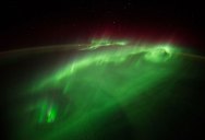
2. Aurora Australis
The Expedition 32 crew onboard the International Space Station, flying an altitude of approximately 240 miles, recorded a series of images of Aurora Australis, also known as the Southern Lights, on July 15, 2012. NASA astronaut Joe Acaba, flight engineer, recorded the series of images from the Tranquility node. The Canadarm2 robot arm is in the foreground.
3. Eastern Seaboard at Night
An Expedition 30 crew member aboard the International Space Station took this nighttime photograph of much of the Atlantic coast of the United States. Large metropolitan areas and other easily recognizable sites from the Virginia/Maryland/Washington, D.C. area are visible in the image that spans almost to Rhode Island. Boston is just out of frame at right. Long Island and the New York City area are visible in the lower right quadrant. Philadelphia and Pittsburgh are near the center. Parts of two Russian vehicles parked at the orbital outpost are seen in left foreground.
4. Alaska’s Brooks Range
Mountains in Alaska’s Brooks Range seen during the IceBridge survey flight from Thule, Greenland to Fairbanks, Alaska.
5. Rub’ al Khali, Arabia
The Rub’ al Khali is one of the largest sand deserts in the world, encompassing most of the southern third of the Arabian Peninsula. It includes parts of Oman, the United Arab Emirates and Yemen. The desert covers an area larger than France. Largely unexplored until recently, the first documented journeys made by Westerners were those of Bertram Thomas in 1931 and St. John Philby in 1932. This image was acquired on Dec. 2, 2005 by the Advanced Spaceborne Thermal Emission and Reflection Radiometer, or ASTER, aboard NASA’s Terra Earth-orbiting satellite.
6. The Water Planet
Viewed from space, the most striking feature of our planet is the water. In both liquid and frozen form, it covers 75% of the Earth’s surface. It fills the sky with clouds. Water is practically everywhere on Earth, from inside the planet’s rocky crust to inside the cells of the human body.
7. Storm Cell Over the Southern Appalachian Mountains
This storm cell photo was taken from NASA’s high-altitude ER-2 aircraft on May 23, 2014, during a study aimed at gaining a better understanding of precipitation over mountainous terrain.
8. An Astronaut’s View from Space
NASA astronaut Reid Wiseman tweeted this photo from the International Space Station on Tuesday morning, Sept. 2, 2014. “My favorite views from #space – just past #sunrise over the ocean,” the Expedition 40 astronaut tweeted.
9. Venice Lagoon
A narrow barrier island protects the Lagoon of Venice from storm waves in the northern Adriatic Sea, and breakwaters protect inlets to the lagoon. Red tiles on the roofs of Venice contrast with the grays of the sister city of Mestre, and the cities are joined by a prominent causeway. What appears to be another causeway joining the island to the airport (top right) is actually the combined wakes of many boats and water taxis shuttling between them. Small, bright agricultural fields on well-drained soils (top left) contrast with the darker vegetation of back-bay swamps, where fishing is a popular pastime.
10. Earth at Night
This new global view of Earth’s city lights is a composite assembled from data acquired by the Suomi National Polar-orbiting Partnership (NPP) satellite. The data was acquired over nine days in April 2012 and 13 days in October 2012. It took 312 orbits to get a clear shot of every parcel of Earth’s land surface and islands.
11. Iberian Peninsula at Night
One of the Expedition 40 crew members aboard the International Space Station recorded this early evening photo of the entire Iberian Peninsula (Spain and Portugal) on July 26, 2014. Part of France can be seen at the top of the image and the Strait of Gibraltar is visible at bottom, with a very small portion of Morocco visible near the lower right corner.
12. Windswept Valleys in Northern Africa
Expedition 40 Flight Engineer Alexander Gerst of the European Space Agency posted this photograph of windswept valleys in Northern Africa, taken from the International Space Station, to social media on July 6, 2014.
13. Exploring the World’s Protected Areas from Space
A new book released this week highlights how the view from space with Earth-orbiting sensors is being used to protect some of the world’s most interesting, changing, and threatened places. From space, Egmont National Park in New Zealand shows the benefits and limitations of protected areas. In this Landsat 8 image acquired on July 3, 2014, the park, with Mt. Taranaki at its center, was established in 1900. This isolated island of protected forest (dark green areas) is surrounded by once-forested pasturelands (light and brown green).
14. Earth’s Vital Signs
ASA launched the Earth Observing System’s flagship satellite “Terra,” named for Earth, on December 18, 1999. Terra has been collecting data about Earth’s changing climate. On February 24, 2000, sensors on NASA’s Terra satellite began opening their shutters and making their first observations.
15. Volcanic Smog and Sunglint in the Vanuatu Archipelago
On Jan. 7, 2014 NASA’s Aqua satellite passed over the Vanuatu Archipelago, capturing this true-color image showing a broad plume of “vog” (volcanic smog) and ash.
16. An Astronaut’s View from Station
A view of Earth as seen from the Cupola on the Earth-facing side of the International Space Station. Visible in the top left foreground is a Russian Soyuz crew capsule. In the lower right corner, a solar array panel can be seen. This photo was taken from the ISS on June 12, 2013.
17. Satellite View of the Americas on Earth Day
NOAA’s GOES-East satellite captured this stunning view of the Americas on Earth Day, April 22, 2014 at 11:45 UTC/7:45 a.m. EDT. The data from GOES-East was made into an image by the NASA/NOAA GOES Project at NASA’s Goddard Space Flight Center in Greenbelt, Md.
18. Another World
This other worldly landscape is actually Dagze Co, one of many inland lakes in Tibet. In glacial times, the region was considerably wetter, and lakes were correspondingly much larger, as evidenced by the numerous fossil shorelines that circle the lake and attest to the presence of a previously larger, deeper lake. Over millennia changes in climate
19. NASA’s Terra Satellite Sees Shadows of Solar Eclipse
During the morning of March 20, 2015, a total solar eclipse was visible from parts of Europe, and a partial solar eclipse from northern Africa and northern Asia. NASA’s Terra satellite passed over the Arctic Ocean on March 20 at 10:45 UTC (6:45 a.m. EDT) and captured the eclipse’s shadow over the clouds in the Arctic Ocean.
20. Storm Clouds Over the Atlantic Ocean Near Brazil
One of the Expedition 36 crew members aboard the International Space Station used a 50mm lens to record this image of a large mass of storm clouds over the Atlantic Ocean near Brazil and the Equator on July 4, 2013. A Russian spacecraft, docked to the orbiting outpost, partially covers a small patch of sunglint on the ocean waters in a break in the clouds.
21. Great Lakes and Central U.S. Viewed From the International Space Station
From the International Space Station, Expedition 42 Flight Engineer Barry Wilmore took this photograph of the Great Lakes and central U.S. on Dec. 7, 2014, and posted it to social media.
22. Earth, Moon, Hubble
Space Shuttle Discovery’s crew witnessed this bright full moon from orbit during a December 1999 mission that included servicing the Hubble Space Telescope (the top of which is seen on the right). To the left is Earth’s horizon; the full moon on that day, Dec. 22, was brighter than average because it was full at nearly the same time it was at its closest to the Earth at a time when the Earth was relatively close to the sun.
23. A Sky View of Earth From Suomi NPP
This composite image of southern Africa and the surrounding oceans was captured by six orbits of the NASA/NOAA Suomi National Polar-orbiting Partnership spacecraft on April 9, 2015, by the Visible Infrared Imaging Radiometer Suite (VIIRS) instrument. Tropical Cyclone Joalane can be seen over the Indian Ocean.
24. Wonders in the Antarctic Sky
An Operation IceBridge project scientist took this Nov. 24, 2013 photograph of a multi-layered lenticular cloud hovering near Mount Discovery, a volcano about 70 kilometers (44 miles) southwest of McMurdo Station on Antarctica’s Ross Island.
25. Flying Through an Aurora
European Space Agency astronaut Alexander Gerst posted this photograph taken from the International Space Station to social media on Aug. 29, 2014, writing, “words can’t describe how it feels flying through an #aurora. I wouldn’t even know where to begin….”
26. Earthrise
Apollo 8, the first manned mission to the moon, entered lunar orbit on Christmas Eve, Dec. 24, 1968. That evening, the astronauts-Commander Frank Borman, Command Module Pilot Jim Lovell, and Lunar Module Pilot William Anders-held a live broadcast from lunar orbit, in which they showed pictures of the Earth and moon as seen from their spacecraft. Sa